Mapping the Grand Canal: HN-400M Multibeam Bathymetry on China's Inland Waterways
2026-06-17
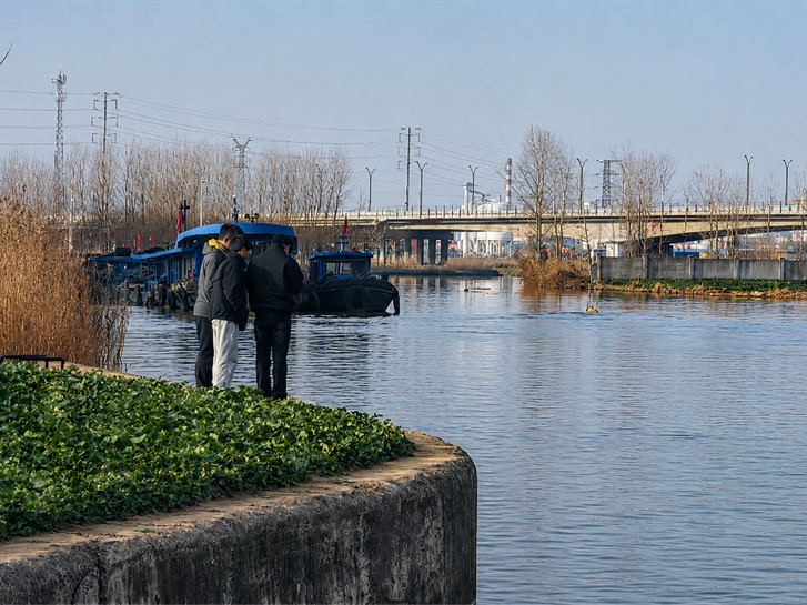
The Jing-Hang Grand Canal is one of China's busiest inland navigation arteries and a strategic golden waterway connecting the north and the south. With the 14th Five-Year Plan now in full execution, the country is accelerating its national programme to build an electronic navigation chart, a so-called "one-map" digital system, across high-grade inland channels. Precision underwater terrain measurement has become a foundational requirement. CHC Navigation recently deployed the HN-400M multibeam echosounder on an Apache 6 unmanned survey vessel for the bathymetric survey of the Huai'an to Lianshui and Yangzhou to Gaoyou sections of the Grand Canal, providing reliable base data for the canal's smart-waterway and electronic-chart programmes.
Why Traditional Manned-Vessel Surveys Struggle on the Grand Canal
Conventional survey work on the Grand Canal relies on manned survey vessels carrying single-beam echosounders. The model is operationally cumbersome: in busy navigation channels, crews must repeatedly negotiate right-of-way with passing cargo vessels; where no suitable launch point exists, equipment has to be carried in by hand; and in turbid, sediment-rich water, single-beam echosounders frequently return large depth errors and miss the seabed entirely in patches. Five operational constraints recur across canal sections:
Shallow water: Manned survey vessels are prone to grounding along the banks and across shoaler reaches.
Heavy navigation traffic: Coordinating right-of-way with commercial vessels slows the work and breaks survey-line continuity.
Turbid water: High-sediment water defeats single-beam penetration and lowers result accuracy.
Floating vegetation: Drifting weeds tangle in manned-vessel propellers and force downtime.
Steep banks and complex geometry: Underwater slopes are unsafe for manned vessels to navigate close to.
HN-400M Multibeam on Apache 6 USV: the Grand Canal Deployment
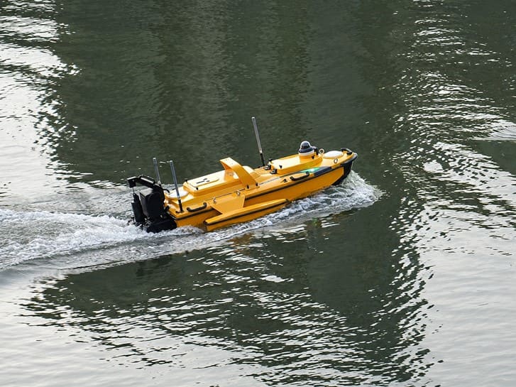
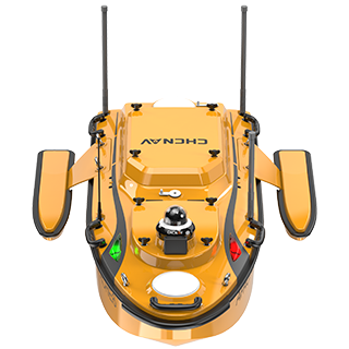
For the Huai'an-Lianshui and Yangzhou-Gaoyou sections, the CHC Navigation team adopted the combination of the Apache 6 unmanned survey vessel and the HN-400M multibeam echosounder, applying the strengths of both platforms to the canal's specific survey challenges.
Bathymetric survey of the Grand Canal using the Apache 6 unmanned survey vessel equipped with the HN-400M multibeam echosounder.
The Apache 6 USV has a shallow draft and a compact form factor that suits shallow-water work. It supports hot-swap batteries, runs for more than six hours per charge at standard cruising speed (around 2 m/s), can operate at night to avoid commercial traffic peaks, and does not need to coordinate right-of-way with other vessels: operators stand on the bank and run the survey from there. Combined with the lightweight HN-400M, the full system can be set up and operated by a survey crew of two, sharply cutting labour and operating cost compared with manned-vessel surveys.
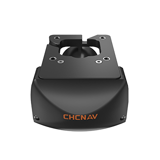
The HN-400M itself is built to four engineering specifications that match the Grand Canal conditions: dual-frequency operation switchable between 400 kHz and 550 kHz; a 145-degree wide swath equal to roughly six times water depth; an integrated 0.03-degree IMU for centimeter-class motion compensation; and a 3.5 kg system weight that mounts on a compact USV with no specialised lift. The Apache 6 navigates with trajectory accuracy better than 0.2 m, and the combined data products meet IHO-S-44 special-order requirements, the highest accuracy class for shallow-water bathymetric work.
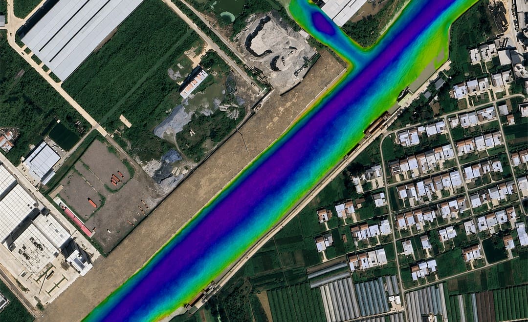
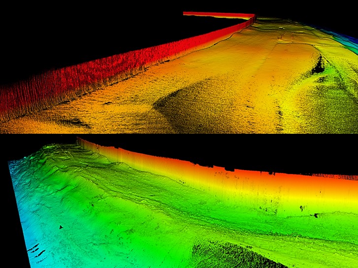
High-density multibeam bathymetric data from the Grand Canal survey, overlaid on a satellite view of the channel; colour gradient indicates depth across the surveyed reach.
Field Findings on the Two Surveyed Sections
The two canal sections presented different combinations of the operational constraints listed above. In reaches with floating vegetation and steep underwater slopes, the HN-400M's dense, full-coverage beam pattern delivered a high-fidelity reconstruction of the seabed, with enough resolution to clearly identify the working tracks left by trailing-suction hopper dredgers operating in the channel.
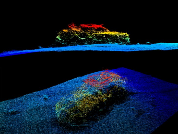
On the Yangzhou-Gaoyou section, the survey detected what appeared to be a submerged SUV-class vehicle on the canal bed, an obstruction that posed a significant safety hazard to navigation and that would not have been caught by a conventional single-beam survey. The finding was passed to the responsible waterway authority for follow-up clearance work.
Left: Point-cloud model of a submerged vehicle detected during the Grand Canal survey. Right: High-density bathymetric point cloud of underwater terrain collected across the surveyed canal section.
Survey Deliverables and Downstream Use
The deliverables for the Grand Canal job were a high-precision DEM, a set of bathymetric contour maps, and a project technical report. The survey produced a high data density on the order of 5,000 points per square metre with point spacing under 0.03 m, comfortably exceeding the project specification. The combined Apache 6 plus HN-400M data product meets the IHO-S-44 special-order standard for shallow-water bathymetric accuracy, the level required for high-grade inland navigation chart compilation.
The relevant waterway management authority used the survey output for three immediate purposes: high-precision underwater terrain review, drafting of channel cross-section diagrams, and assessment of navigation impact against the road design parameter files for upcoming construction segments. The data is now also feeding into the section's contribution to the national electronic navigation chart and into the downstream smart-waterway management programme for the Grand Canal corridor.
Multibeam Sonar, USVs, and Bathymetric Data in Context
Multibeam sonar principles. A single-beam echosounder fires one acoustic pulse straight down and reports a single depth value. A multibeam system fires a fan-shaped array of beams across the swath beneath the vessel and reports a depth for every beam in the fan, producing hundreds or thousands of soundings per ping. This is what makes full-coverage seabed mapping at canal scale feasible at the data densities modern inland-waterway chart programmes require.
The role of unmanned survey vessels. Shallow-draft USVs unlock parts of the survey envelope that manned vessels cannot safely reach: shoals, vegetated reaches, steep banks, and stretches with continuous commercial traffic. The Apache 6 in the Grand Canal job carried the HN-400M with room to spare, ran continuous lines without right-of-way coordination, and was deployed and operated by two people. The economics of inland waterway survey work shift sharply when this becomes the standard platform.
Bathymetric data for digital nav charts and smart waterways. The final deliverable of a survey is not the survey itself but the data layer it feeds. High-density, high-accuracy bathymetry is the foundational layer for the electronic navigation chart, for channel-maintenance dredging plans, and for the smart-waterway traffic-management platform. As more inland reaches move to USV-multibeam coverage, the refresh cycle for these downstream systems gets faster and the chart stays closer to ground truth.
HN-400M for Inland Waterway Bathymetric Survey
The HN-400M sits inside the broader CHCNAV marine and hydrographic surveying solution alongside ADCP river-flow products such as the RS3600D and single-beam echosounders such as the D60. For inland navigation chart programmes, port and harbour dredging, lake and reservoir surveys, river monitoring, and underwater inspection, the HN-400M is the dual-frequency multibeam answer in the CHCNAV lineup.
Looking Ahead
CHC Navigation continues to invest in marine and hydrographic surveying, applying advanced technology and proven products to deliver precise solutions for water-resource and waterway-engineering projects. The Grand Canal deployment is one project in that ongoing programme.
____
About CHC Navigation
CHC Navigation (CHCNAV) develops advanced mapping, navigation, and positioning solutions designed to increase productivity and efficiency. Serving industries such as geospatial, agriculture, machine control and autonomy, CHCNAV delivers innovative technologies that empower professionals and drive industry advancement. With a global presence spanning over 140 countries and a team of more than 2,200 professionals, CHC Navigation is recognized as a leader in the geospatial industry and beyond. For more information about CHC Navigation [Huace:300627.SZ], please visit: https://geospatial.chcnav.com/about/overview