Hydrographic Survey Equipment Guide: ADCP vs Echosounder vs Multibeam
2026-06-22
Hydrographic survey work covers a wide range of questions about water: how deep is the channel, what does the riverbed look like, how fast is the current, and how is all of that changing over time. No single instrument answers every one of those questions. Choosing hydrographic survey equipment is mostly a matter of matching the instrument to the question, the water body, and the platform that will carry it. This guide walks through the three core instrument families used in modern bathymetric mapping, single-beam echosounders, multibeam echosounders, and acoustic Doppler current profilers, and explains where each one fits.
What Hydrographic Survey Equipment Measures
At its core, a hydrographic survey produces two kinds of data: the shape of the bed beneath the water (bathymetry), and the behaviour of the water itself (current and flow). Acoustic instruments do the work, sending a sound pulse into the water and timing its return. The differences between instrument types come down to how many beams they use, how wide an area they cover, and whether they are built to measure depth, flow, or both.
Three measurement jobs recur across almost every project:
Depth and bed shape: mapping the seabed, riverbed or lakebed for navigation charts, dredging plans, and volume calculations. This is the work of echosounders.
Water flow and discharge: measuring current speed and direction through the water column, and calculating river discharge. This is the work of acoustic Doppler current profilers.
Positioning and motion: tying every sounding to an accurate position and correcting for the motion of the survey platform. This is the work of the GNSS and inertial system that underpins the whole survey.
CHCNAV hydrographic survey equipment for bathymetry, water measurement, and data collection.
Single-Beam Echosounders
A single-beam echosounder is the most direct depth instrument. It fires one acoustic pulse straight down and reports a single depth value at each ping. Run a survey line across the water and the result is a profile of depths along that track. It is simple, robust, light, and the most affordable entry point into bathymetric survey work.
Single-beam systems suit projects where full-coverage seabed imaging is not required: routine channel-depth checks, reservoir and lake level surveys, river cross-sections, and inspection work where a representative depth profile along set lines is enough. Dual-frequency single-beam models add a second job, using a low frequency to penetrate soft sediment and a high frequency to return the hard bed, so the survey captures both the surface of the silt and the solid bottom beneath it.
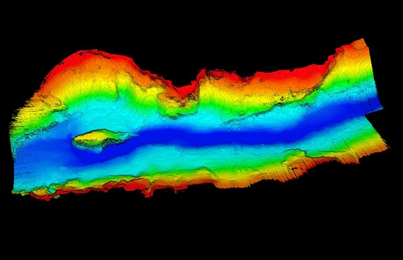
A multibeam echosounder answers the limitation of the single beam. Instead of one pulse straight down, it fires a fan-shaped array of beams across a swath beneath the vessel and reports a depth for every beam in the fan, producing hundreds or thousands of soundings per ping. As the vessel moves forward, those swaths build into a continuous, full-coverage three-dimensional model of the bed rather than a set of spaced profiles.
Multibeam is the instrument of choice when the survey needs complete coverage and high detail: port and harbour surveys, dredging volume measurement, underwater structure inspection, and high-grade navigation chart compilation. The swath width is usually expressed as a multiple of water depth, so a single pass covers a band several times wider than the depth below the vessel, which is what makes full-coverage mapping practical at scale. The trade-off is cost and complexity: multibeam systems need accurate motion compensation and careful calibration to turn the raw beam data into a clean surface.
The CHCNAV HQ-400 compact multibeam echosounder is built for this work on a compact platform, bringing full-coverage bathymetry to small and unmanned vessels.
Acoustic Doppler Current Profilers (ADCP)
An acoustic Doppler current profiler measures something the echosounders do not: the movement of the water. It uses the Doppler shift of sound reflected off particles suspended in the water to measure current speed and direction at many depths through the water column at once, building a profile of flow from surface to bed. Paired with a cross-section of the channel, an ADCP also calculates discharge, the total volume of water moving past a point per second, which is the key figure in hydrology and water-resource management.
ADCPs are the instrument for river and stream gauging, flood monitoring, irrigation and water-resource studies, and any project where flow rather than only depth is the target. Many ADCPs also record a bottom-track depth, so a single deployment can return both a flow profile and a depth measurement along the track.
Channel checks, reservoir and lake surveys, river cross-sections, budget-sensitive depth work
Multibeam echosounder
Depth across a wide swath
Full-coverage 3D bed model
Port and harbour surveys, dredging volumes, structure inspection, high-grade nav charts
ADCP
Current speed, direction and discharge
Flow profile through the water column
River and stream gauging, flood and flow monitoring, water-resource studies
The three are complementary rather than competing. A complete water-resource or waterway programme often uses all three: an ADCP for discharge, a single-beam for routine depth lines, and a multibeam for the detailed full-coverage sections that matter most. The right starting point depends on whether the project is primarily about depth, detail, or flow.
The Platform Matters as Much as the Instrument
An echosounder or ADCP is only as good as the platform carrying it and the positioning behind it. Two factors decide the quality of the final data as much as the sensor itself.
Unmanned survey vessels
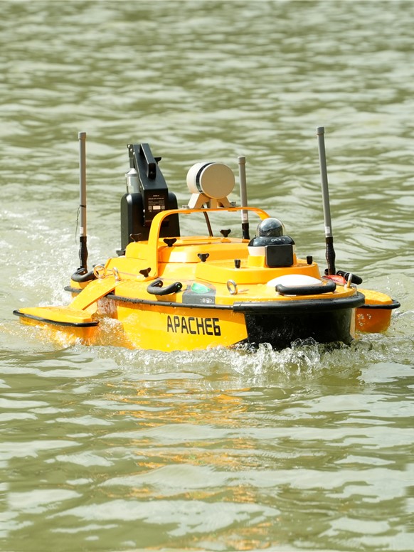
Shallow-draft unmanned survey vessels reach parts of the survey envelope that crewed boats cannot work safely: shoals, vegetated reaches, steep banks, and stretches with continuous commercial traffic. A compact USV can carry a single-beam, multibeam or ADCP payload, runs continuous survey lines without coordinating right-of-way, and can be deployed and operated by a small crew from the bank. The APACHE 4 unmanned survey vessel is one example of a lightweight platform built to carry these payloads into difficult water.
Positioning and motion compensation
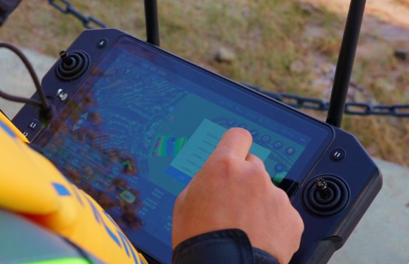
Every sounding has to be tied to an accurate position, and on a moving vessel it also has to be corrected for roll, pitch and heave. That is the job of an integrated GNSS and inertial system. Without accurate positioning and motion compensation, even a high-end multibeam returns a distorted surface. This is why hydrographic survey equipment is specified as a system, the acoustic sensor, the positioning unit, and the platform together, rather than as a sensor alone.
How to Choose Hydrographic Survey Equipment
A short set of questions narrows the choice quickly:
Depth or flow? If the project is about how much water is moving, start with an ADCP. If it is about the shape of the bed, start with an echosounder.
Profile or full coverage? If representative depth lines are enough, a single-beam echosounder is the efficient choice. If the work needs a complete, high-detail surface, a multibeam echosounder is the answer.
What water, and what access? Shallow, vegetated, fast-flowing or traffic-heavy water points toward a compact unmanned survey vessel rather than a crewed boat.
What accuracy class? Navigation chart compilation and engineering work carry strict accuracy standards that drive both the sensor grade and the positioning requirement.
CHCNAV Hydrographic and Marine Survey Equipment
CHC Navigation builds hydrographic survey equipment across all three instrument families and the platforms that carry them: ADCP current profilers in the RS series, single-beam echosounders in the D series, the HQ-400 multibeam echosounder, and the APACHE series of unmanned survey vessels. They sit inside the broader CHCNAV hydrographic surveying and bathymetric mapping solution, which brings the sensors, positioning and platforms together for inland waterway charting, port and harbour surveys, river and reservoir work, flood and flow monitoring, and underwater inspection.
For teams building or expanding a hydrographic capability, the practical path is to match the instrument to the measurement, the platform to the water, and the positioning to the accuracy class, then bring them together as one system rather than a collection of parts.
____
About CHC Navigation
CHC Navigation (CHCNAV) develops advanced mapping, navigation, and positioning solutions designed to increase productivity and efficiency. Serving industries such as geospatial, agriculture, machine control and autonomy, CHCNAV delivers innovative technologies that empower professionals and drive industry advancement. With a global presence spanning over 140 countries and a team of more than 2,200 professionals, CHC Navigation is recognized as a leader in the geospatial industry and beyond. For more information about CHC Navigation [Huace:300627.SZ], please visit: https://geospatial.chcnav.com/about/overview
Have a question about our hydrographic surveying solutions?