GNSS Deformation Monitoring on the World's Highest Bridge
2026-06-11
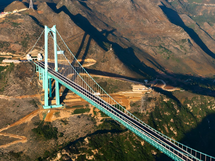
At 626.01 metres above the river below, the Huajiang Canyon Bridge in Guizhou, China, was certified by Guinness World Records on 28 April as the highest bridge in the world. Behind that record sits a long programme of precise positioning work. From the closure of the main span during construction to round-the-clock monitoring once the bridge opened to traffic, CHCNAV GNSS equipment has helped safeguard the structure, and CHCNAV unmanned survey vessels and RTK receivers were used to measure the record-setting height itself.
Precise Positioning for an Efficient Main-Span Closure
During the closure phase of construction, lifting the long-span steel truss girders into place demanded extreme precision in high-altitude work. To solve this, the intelligent cable-crane lifting system was built around satellite positioning. CHCNAV deployed the P5 GNSS reference station together with CHCNAV integrated GNSS monitoring receivers, using millimetre-level positioning to track the height of the hoisting winches and the position of the traction winches in real time. That data gave the crews reliable support for position adjustment, alignment control and precise girder matching, helping the closure proceed to a high standard.
In the CHCNAV lineup, that monitoring role is filled by the H3 integrated GNSS and MEMS monitoring receiver, which pairs a multi-constellation GNSS board with a built-in inertial sensor for real-time displacement tracking.
Continuous Structural Health Monitoring for Safe Operation
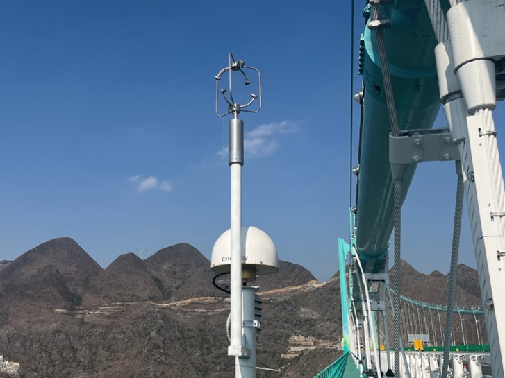
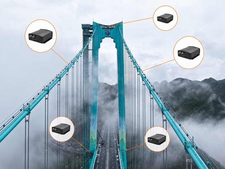
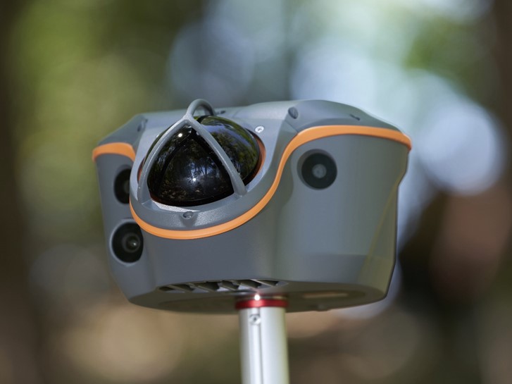
As a suspension bridge spanning a deep canyon and a river, the Huajiang Canyon Bridge faces long-term exposure to environmental erosion and load cycling. Identifying deformation anomalies and safety risks early is what keeps the structure safe across decades of service. To do that, the management authority installed ten CHCNAV GNSS monitoring receivers at the critical points of the structure: mid-span, the main cables and the bridge towers.
A CHCNAV GNSS monitoring receiver installed on the Huajiang Canyon Bridge, one of ten units placed at mid-span, the main cables and the bridge towers.
The receivers track all frequency bands across the GNSS constellations and, through intelligent signal identification and adaptive interference suppression, capture mid-span deflection, tower tilt, main-cable displacement and foundation settlement at high precision and high frequency. An IP68 protection rating lets them stand up to harsh outdoor conditions, and a working range of minus 40 to plus 85 degrees Celsius keeps them stable through the canyon's temperature swings, supporting continuous, unattended monitoring around the clock.
GNSS monitoring receivers distributed across the suspension bridge, with units at the towers, along the main cables and at the deck, each reporting position continuously so deflection, tilt, displacement and settlement can be tracked together.
How GNSS Structural Monitoring Works
Structural monitoring with GNSS rests on a simple idea applied with high rigour: a receiver fixed to a structure reports its own position continuously, and any movement of the structure shows up as a change in that position. The engineering challenge is resolving movements of a few millimetres on a structure that is itself moving with wind, traffic and thermal expansion, and doing it reliably over years rather than minutes.
A monitoring-grade GNSS receiver addresses this in several ways. It tracks every available signal band across multiple constellations, which gives it redundancy when part of the sky is blocked and improves the geometry of the position solution. It combines carrier-phase processing with a reference station, in this case the P5, so that positions are resolved relative to a stable benchmark rather than in absolute terms, pushing accuracy to the millimetre level. Where an inertial sensor is integrated, as in the H3, the receiver can also separate genuine structural movement from short-term signal noise. The result is a continuous record of four key behaviours that engineers watch on any large bridge:
Deflection: the vertical movement of the deck at mid-span under traffic and thermal load.
Tilt: the angular movement of the bridge towers, which reveals uneven loading or foundation issues.
Displacement: the movement of the main cables, the primary load-bearing elements of a suspension bridge.
Settlement: the slow vertical movement of the foundations, which can signal ground or scour problems below.
Because the receivers log these values continuously rather than during periodic inspections, the monitoring system builds a baseline of normal behaviour and flags departures from it. A reading that drifts outside the expected envelope becomes an early warning long before the change would be visible to an inspector, which is the core value of a permanent monitoring installation over manual survey campaigns alone.
Reliable Positioning in a Demanding Canyon Environment
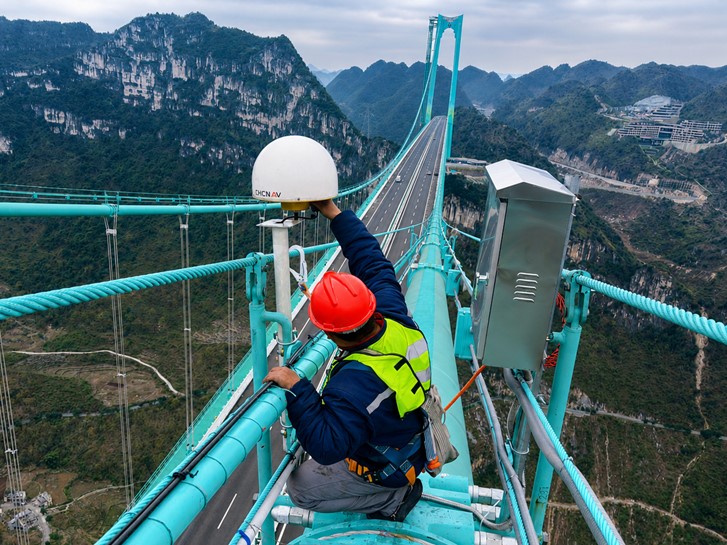
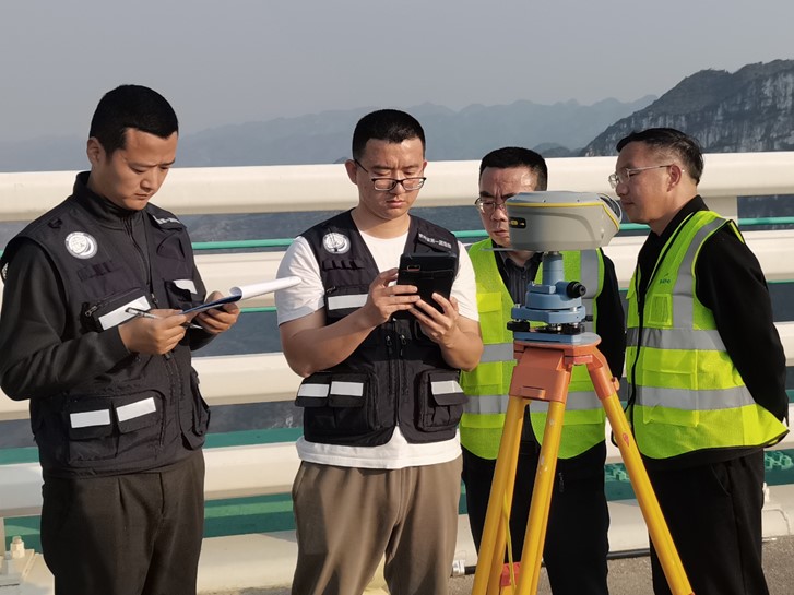
Before the bridge could be certified as the world's highest, the vertical distance from the deck to the water surface had to be established with an exact, unarguable figure. The surveying team from the First Institute of Surveying and Mapping of Guizhou Province combined high-precision GNSS positioning with unmanned survey vessels to solve the measurement problems specific to a high-relief canyon: controlling accuracy across an extreme vertical drop, and working in difficult conditions on and around the structure.
When the water level dropped and the channel narrowed too far for a crewed boat, the APACHE 4 unmanned survey vessel, weighing only 13 kg, was light enough for the team to carry on foot down to the measurement point beneath the bridge. With its built-in high-precision GNSS positioning supporting RTK and PPK, it captured the water-surface elevation data efficiently and accurately. On the bridge deck above, the ViLi i100 GNSS RTK receiver connected to the regional NTRIP network to stake out the corresponding survey points with precision.
The survey team measuring the deck-to-water height of the Huajiang Canyon Bridge ahead of the Guinness World Records certification.
The canyon environment was the real test. Strong winds, mountain occlusion and reflection off the water surface all interfere with GNSS signal transmission and easily trigger multipath errors, which is the single biggest threat to positioning stability in a setting like this. Equipped with multi-source data fusion positioning, the ViLi i100 identifies and suppresses the multipath errors caused by canyon terrain, water-surface reflection and mountain occlusion, keeping repeated measurements consistent and reliable. After repeated cross-checking of the data, the deck-to-water height was fixed at 626.01 metres, and the Guinness World Records certification was confirmed.
CHCNAV Monitoring Receivers for Bridges and Critical Infrastructure
The receivers used on the Huajiang Canyon Bridge sit inside the broader CHCNAV infrastructure monitoring and deformation solution. The H3 integrated GNSS and MEMS monitoring receiver is built for exactly this role: a sealed, IP68-rated unit that tracks multi-constellation signals, integrates an inertial sensor for stable deformation capture, and operates unattended across a wide temperature range. Paired with a P5 GNSS reference station as the benchmark, a network of these receivers turns a bridge, dam, slope or high-rise structure into a continuously monitored asset.
For bridge deformation monitoring, dam and reservoir safety, landslide and slope monitoring, and high-rise and foundation settlement work, CHCNAV provides the GNSS receivers, reference stations and the monitoring solution that brings them together. The Huajiang Canyon Bridge is one project in that ongoing programme, and a demanding proof of what continuous GNSS monitoring can do on the most extreme structures in the world.
____
About CHC Navigation
CHC Navigation (CHCNAV) develops advanced mapping, navigation, and positioning solutions designed to increase productivity and efficiency. Serving industries such as geospatial, agriculture, machine control and autonomy, CHCNAV delivers innovative technologies that empower professionals and drive industry advancement. With a global presence spanning over 140 countries and a team of more than 2,200 professionals, CHC Navigation is recognized as a leader in the geospatial industry and beyond. For more information about CHC Navigation [Huace:300627.SZ], please visit: https://geospatial.chcnav.com/about/overview
Find the Right Infrastructure Monitoring Solution
Improve long-term stability and safety with expert guidance on GNSS-based structural health monitoring systems.