Mobile Mapping Systems: A Smarter Approach to Geospatial Data Collection
2025-11-28
Introducing Mobile Mapping: Capturing Geospatial Data with Speed and Precision
Mobile Mapping Systems (MMS) mark a significant advancement in how geospatial data is captured and applied. These platforms integrate technologies such as LiDAR, GNSS, inertial measurement units (IMUs), and high-resolution imaging into a unified system capable of collecting dense spatial information while in motion. Unlike traditional surveying methods that capture isolated points, MMS generate continuous datasets that represent the physical environment in greater detail and at higher speed.
The growing adoption of mobile mapping is driven by the need for more granular and timely geospatial data, particularly in support of smart city development, utility management, and Building Information Modeling (BIM). Traditional methods are often too labor-intensive, time-consuming and limited in the scope of information they can capture. In contrast, a single mobile mapping mission can capture the equivalent of weeks’ worth of static survey data, streamlining workflows and lowering operational costs.
Advances in LiDAR resolution, GNSS precision, and SLAM technology have made mobile mapping more accurate and reliable than ever before. Advanced systems can capture millions of 3D points per second with sub-centimeter accuracy and maintain positioning in environments with limited or no satellite visibility. These developments have positioned mobile mapping systems as a key enabler for data-driven infrastructure planning and geospatial intelligence.
From Road to Reality: Inside the Mobile Mapping System Workflow
Step One: Mission Planning and System Setup
The mobile mapping process begins well before arriving on site. During the planning phase, survey teams use mission planning software to define project boundaries, optimize driving routes, and determine ground control point (GCP) locations. This step ensures efficient data coverage and supports accurate georeferencing.
System preparation follows, including mounting the MMSon a vehicle, calibrating the sensors, and running diagnostic checks to verify system synchronization. The pre-deployment process is critical for achieving reliable results in the field.
Step Two: Capturing High-Density Data on the Move
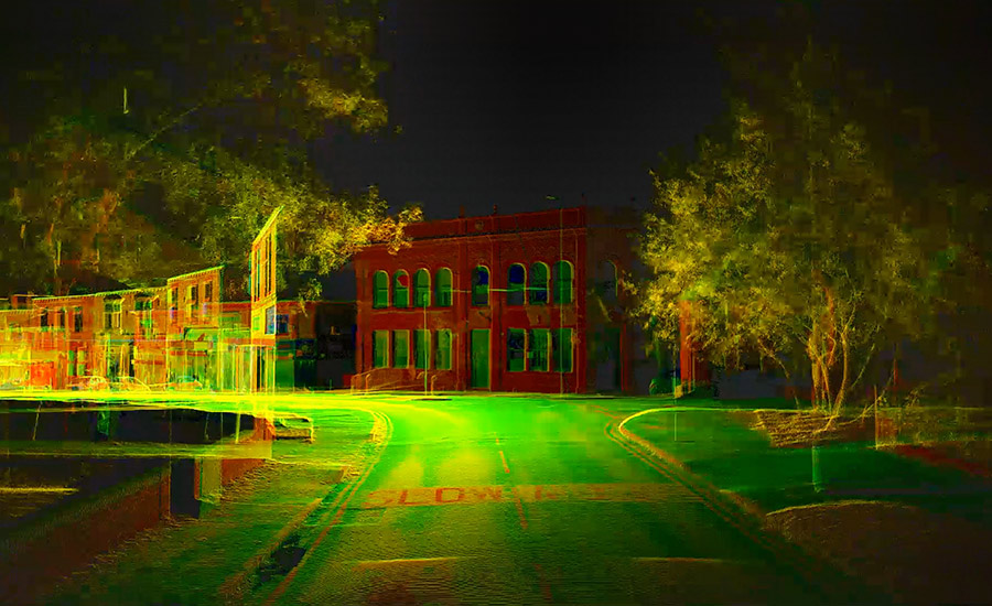
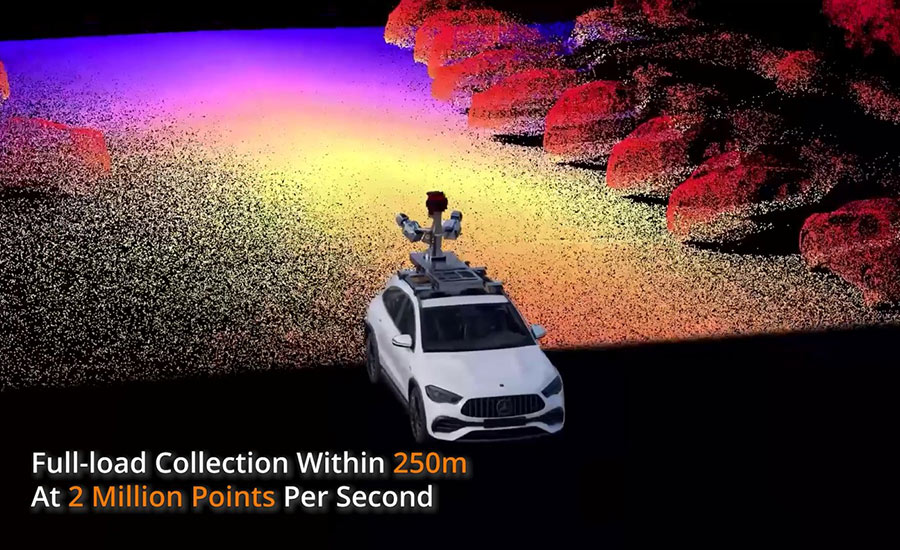
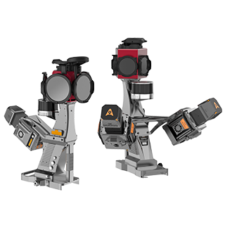
During acquisition, the vehicle travels along the defined routes at controlled speeds (typically between 20 and 60 km/h) to ensure sufficient data density. The AU20 Mobile Mapping System from CHCNAV, for example, features a dual-LiDAR setup capable of collecting up to two million points per second, covering a wide field of view to capture roadway features and surrounding infrastructure.
At the same time, a tightly integrated GNSS/IMU system records the vehicle's position and orientation, creating a precise trajectory. High-resolution panoramic cameras capture imagery that can later be used to enhance the point cloud with photorealistic context. All data streams are time-stamped and stored for post-processing.
Expanding Coverage: SLAM-Based Mapping for Inaccessible Areas
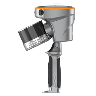
In areas where vehicles cannot operate such as narrow walkways or pedestrian zones, mobile mapping can be extended using portable or wearable configurations. CHCNAV’s RS10 scanner allows operators to map these spaces on foot using SLAM technology, which maintains positioning accuracy without GNSS signals.
The AU20 system can also be adapted for backpack use, offering vehicle-grade precision in areas with limited accessibility. This hybrid approach ensures full spatial coverage while enhancing overall data quality through trajectory fusion.
Streamlined Processing: Turning Field Data into Actionable Insights
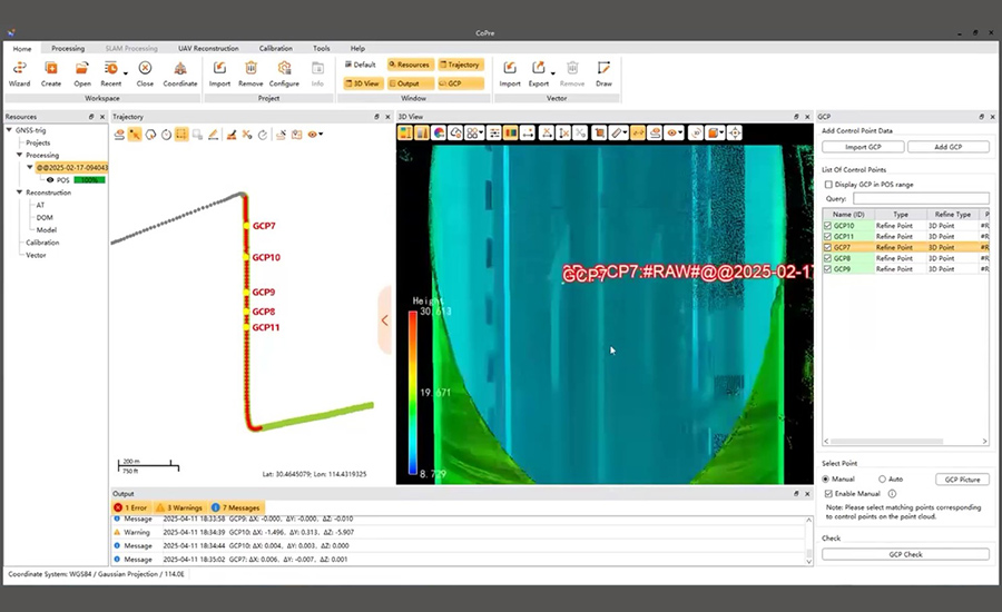
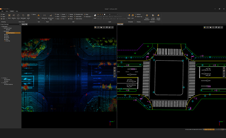
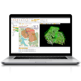
CHCNAV’s integrated software tools streamline the transition from raw data to actionable deliverables. The CoPre and CoProcess platforms support automated AI-powered point cloud cleaning, feature extraction, and panoramic image coloring, significantly reducing manual workload and processing time.
This software ecosystem enables high-throughput workflows for applications such as highway asset inventories, utility corridor mapping, and 3D city modeling. By combining robust data collection with automated processing, CHCNAV shortens the time between fieldwork and delivery, improving both productivity and consistency.
Looking Ahead: The Role of Mobile Mapping Systems in Geospatial Data Acquisition
Mobile mapping has evolved into a foundational technology for geospatial data acquisition. Mobile Mapping Systems like the CHCNAV AU20 MMS offer the flexibility to operate in diverse environments while maintaining the accuracy required for professional surveying and engineering applications.
Paired with a streamlined software ecosystem, mobile mapping system now supports full project lifecycles from planning and collection to analysis and delivery. For organizations working in transportation, urban development, or infrastructure maintenance, adopting mobile mapping technologies offers a clear path to improved efficiency, data quality, and operational insight.
Understanding and applying these tools is increasingly critical in an era where spatial awareness underpins effective decision-making across sectors.
____
About CHC Navigation
CHC Navigation (CHCNAV) develops advanced mapping, navigation and positioning solutions designed to increase productivity and efficiency. Serving industries such as geospatial, agriculture, construction and autonomy, CHCNAV delivers innovative technologies that empower professionals and drive industry advancement. With a global presence spanning over 140 countries and a team of more than 2,000 professionals, CHC Navigation is recognized as a leader in the geospatial industry and beyond. For more information about CHC Navigation [Huace:300627.SZ], please visit: www.chcnav.com