How to Choose the Right Land Surveying Equipment for Your Project
2026-04-02
Choosing the right land surveying equipment can determine whether a project delivers on time and within budget, or becomes a slow, costly series of corrections. With a wide range of tools available, from GNSS smart antennas and RTK receivers to total stations and rugged field controllers, the decision is rarely straightforward. Project type, terrain, accuracy requirements, and workflow all play a role. This guide breaks down the main categories of land survey tools, explains the key factors that should drive your selection, and highlights how specific CHCNAV products address the demands of real-world surveying work. Whether you are handling topographic mapping, boundary surveys, construction layout, or earthwork projects, the right equipment makes a measurable difference.
Understanding the Main Types of Land Surveying Equipment
Before evaluating specific products, it helps to understand what each category of equipment does and where it excels. Modern surveying relies on three core tool types, each suited to different conditions and workflows.
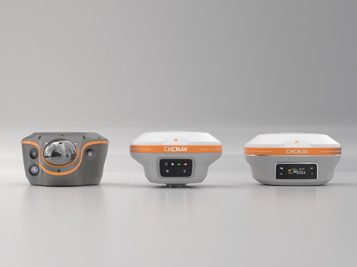
CHC Navigation's GNSS smart antennas provide centimeter-level RTK accuracy with IMU tilt compensation. Paired with a total station, LT800 data collector, and LandStar software, they form a complete field-to-office surveying workflow.
GNSS Smart Antennas
GNSS receivers use satellite signals from multiple constellations, including GPS, GLONASS, BeiDou, and Galileo, to determine precise ground positions. When paired with RTK (Real-Time Kinematic) technology, these systems deliver centimeter-level accuracy in real time without post-processing. GNSS surveying equipment is particularly effective in open terrain where satellite signals are unobstructed, making it the preferred tool for topographic surveys, boundary demarcation, and construction stakeout across large areas.
Modern GNSS smart antennas add inertial measurement units (IMU) that allow the receiver to continue providing accurate positions even when the pole is tilted. This speeds up fieldwork considerably, since surveyors no longer need to level the pole for every reading. Some advanced receivers also integrate cameras and LiDAR for contactless coordinate capture and 3D modelling in environments where direct measurement is difficult or dangerous.
Total Stations
A total station combines electronic distance measurement (EDM) with angle measurement to deliver precise 3D point coordinates. Unlike GNSS, total stations do not depend on satellite signal availability, making them well suited for environments with heavy canopy cover, deep urban canyons, or indoor settings where GNSS signals are unreliable or unavailable.
Total station surveying is the preferred approach for construction setout, structural monitoring, land subdivision, and any scenario requiring measurements with consistent accuracy regardless of sky visibility. Reflectorless models can measure distances to surfaces without a prism, extending their utility to facade surveys, hazardous areas, and large infrastructure projects.
Field Controllers and Software
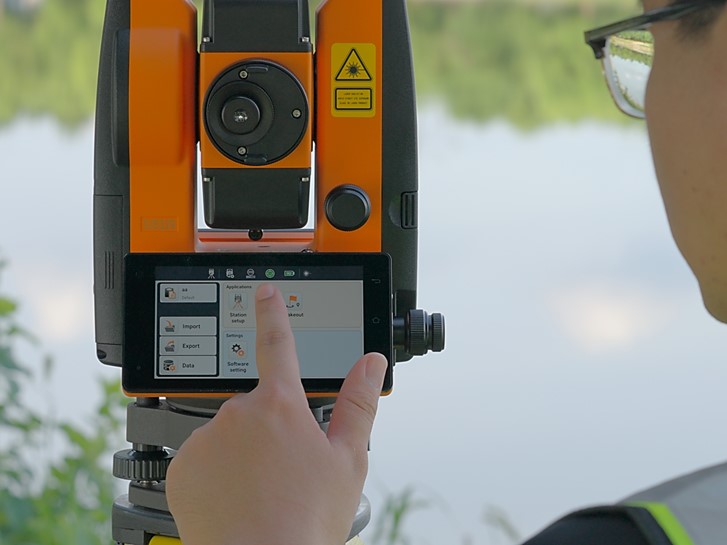
Field controllers, typically rugged tablets or handhelds, connect to the surveying instrument and run dedicated surveying software that manages data collection, stakeout guidance, job file management, and data export. The controller is the interface between the instrument and the surveyor, and its usability, screen readability, and software capability directly affect productivity in the field.
Surveying software packages handle coordinate systems, COGO calculations, design file import, and real-time communication with base stations or network RTK providers. Selecting a controller and software platform that integrates tightly with your hardware eliminates compatibility issues and simplifies the data workflow from field to office.
Key Factors to Consider When Choosing Surveying Equipment
No single piece of equipment is ideal for every job. The following factors should guide your selection process and help you match tools to the specific demands of each project.
Project Type and Working Environment
The nature of the project is the starting point for every equipment decision. Open-sky topographic surveys in agriculture, mining, or infrastructure development are natural fits for GNSS rovers and RTK GPS surveying systems. Urban construction projects with dense building clusters, or surveys conducted under forest canopy, may require total stations or a hybrid approach combining both technologies.
Projects in GNSS-obstructed environments, such as deep excavations or dense vegetation, may benefit from GNSS receivers that integrate LiDAR or visual positioning engines to maintain accuracy when satellite signals are compromised. Understanding the environment before selecting equipment prevents costly surprises on site.
Accuracy Requirements
Different surveying tasks carry different accuracy thresholds. Boundary surveys and cadastral work often require sub-centimeter precision and strict adherence to regulatory standards. Topographic mapping for earthwork planning may tolerate slightly wider tolerances, while reconnaissance surveys can accept decimeter-level accuracy.
RTK GNSS systems can deliver 8mm horizontal and 15mm vertical accuracy under ideal conditions. Total stations offer even tighter angular and distance accuracy for close-range structural work. Confirming the accuracy specification needed before purchase avoids over-specifying and overspending on equipment that exceeds what a project actually requires.
Portability and Ruggedness
Field equipment must survive the conditions it works in. Remote sites, extreme temperatures, rain, dust, and rough handling are realities in construction and mining surveying. Look for ingress protection ratings of IP67 or IP68, which indicate resistance to dust and water immersion. Battery life matters too: a receiver or total station that runs out of charge mid-shift creates delays and data gaps.
Weight and form factor affect how long surveyors can work effectively. Compact, lightweight receivers reduce fatigue on long traverses. Instruments that are easy to mount, level, and operate in the field keep workflows moving without unnecessary downtime.
Software Integration and Data Workflow
Survey data only creates value when it moves efficiently from the field to the office. Equipment that supports common data formats, integrates with CAD and GIS platforms, and connects to cloud-based project management systems reduces manual data handling and transcription errors. A closed-loop workflow, from design import to data collection to deliverable export, shortens project timelines and reduces the risk of version control issues between field and office teams.
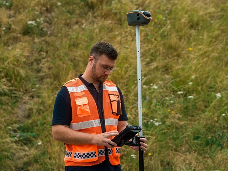
A surveyor collects positioning data using a GNSS RTK receiver, with real-time coordinates and status displayed in the LandStar software.
GNSS Receivers vs Total Stations: Matching Equipment to the Job
A common question among surveyors is whether to invest in GNSS surveying equipment, a total station, or both. The answer depends on the mix of work the team handles.
GNSS RTK systems are faster for covering large areas and work well when multiple points need to be captured over wide extents. A single operator with a GNSS rover can record hundreds of points per day in open terrain with minimal setup time. Network RTK connections eliminate the need to set up a base station, further streamlining operations.
Total stations are indispensable when satellite access is limited or when work requires tight point-to-point accuracy over short distances, such as setting out structural columns, checking as-built dimensions, or monitoring deformation. They also provide a legally defensible measurement chain for cadastral and boundary work in many jurisdictions.
For teams handling diverse project types, having both a GNSS receiver and a total station is often the most practical approach. The two technologies complement each other: GNSS for rapid data capture in open conditions, and the total station for precision work in constrained environments. The key is ensuring both systems share a common data and software platform to avoid duplication of effort when processing and reporting results.
CHCNAV Land Surveying Equipment: Solutions for Every Scenario
CHCNAV offers a range of professional-grade instruments designed to meet the demands of land survey tools used across diverse project types. The following products represent solutions aligned with the selection criteria outlined above.
The CHCNAV i89 is a compact Visual IMU-RTK GNSS receiver built for surveyors who need reliable performance without carrying heavy equipment. Weighing just 750g and rated IP68, it integrates dual cameras, 200Hz Auto-IMU for pole-tilt compensation, and iStar 2.0 ionospheric mitigation technology. Its 16.5-hour battery supports full-day shifts in topographic, mining, and construction survey environments without interruption.
The CHCNAV i93 extends the capability of the i89 with enhanced visual surveying features, including 3D coordinate extraction from imagery, visual stakeout guidance, and 3D modeling support. With 200Hz Auto-IMU and dual cameras, the i93 is suited for topographic surveys, boundary demarcation, as-built documentation, and projects where visual capture adds value alongside traditional GNSS measurement.
For work in GNSS-obstructed or signal-denied areas, the CHCNAV ViLi i100 offers a distinctive solution. This Visual-LiDAR GNSS RTK receiver maintains 5cm positioning accuracy within 20m in GNSS-denied environments using the SFix 2.0 positioning engine. The integrated Vi-LiDAR system captures 3D point clouds using four cameras for contactless survey, and supports earthwork volume calculation with 99.98% accuracy. The i100 is particularly valuable in construction sites with structures, dense tree cover, or below-grade excavations where satellite access is compromised.
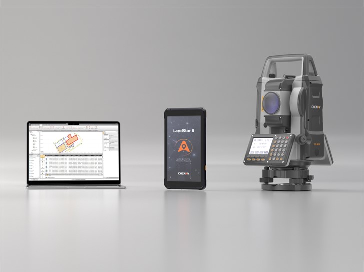
On the total station side, the CHCNAV CTS-M100 is a cost-effective instrument for teams that need reliable performance across topographic surveys, land subdivision, and solar farm layout. Its reflectorless EDM reaches up to 1,500m, and dual-face keyboards simplify operation. Internal storage handles up to 140,000 points, with USB storage support up to 128GB. An 8-hour battery keeps the instrument operational through a full working day.
For more demanding total station applications, the CHCNAV CTS-A100 delivers advanced performance for complex engineering survey and construction projects requiring higher precision and expanded functionality.
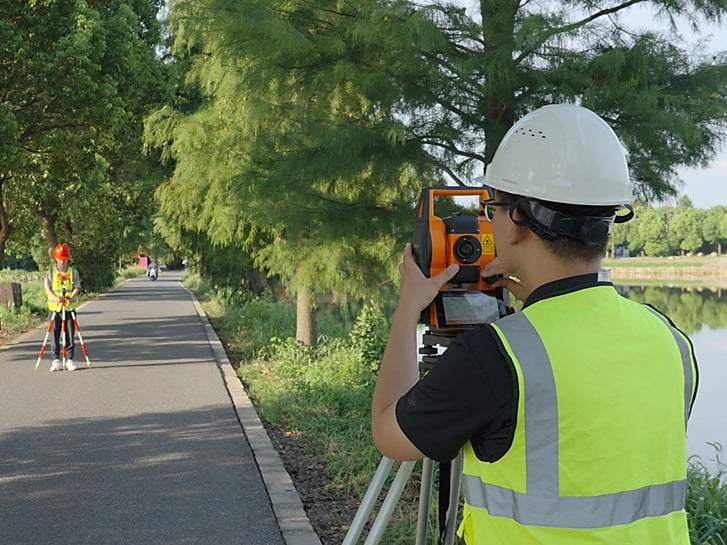
A surveyor operating a total station on a construction site. Total stations provide precise angular and distance measurements in environments where GNSS signals are limited.
Building a Complete Survey Kit
A single instrument rarely constitutes a complete field kit. Pairing the right receiver or total station with a capable controller and integrated software transforms individual instruments into a coherent, productive system.
The CHCNAV LT800 is a rugged field tablet and controller designed to connect with CHCNAV instruments in demanding outdoor conditions. Its high-brightness display maintains visibility in direct sunlight, and its rugged build withstands the physical demands of active construction and survey sites. The LT800 runs CHCNAV's field software and provides a reliable interface for data collection, job management, and real-time instrument control.
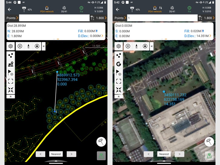
For software, CHCNAV LandStar is a professional surveying and mapping software platform designed to work across the CHCNAV instrument range. LandStar handles GNSS data collection, total station operation, stakeout, road design, and data export to standard formats compatible with AutoCAD, ArcGIS, and other office platforms. Its consistent interface across instrument types means surveyors trained on one CHCNAV product can transition to another with minimal retraining.
Combining the i89 or i93 GNSS receiver with the LT800 controller and LandStar software creates a capable GNSS kit for open-terrain work. Adding a CTS-M100 total station to the same software environment gives the team the flexibility to handle constrained-environment jobs without switching platforms or reprocessing data in multiple systems.
Getting the Most from Your Equipment Investment
Selecting the right land surveying equipment is only the beginning. Maximizing the return on that investment requires attention to how the equipment is used, maintained, and integrated into the broader project workflow.
Training is one of the most undervalued factors in equipment performance. Surveyors who understand the capabilities and limitations of their instruments, including how to configure base-rover setups, manage network RTK connections, and interpret quality indicators, consistently achieve better results than those relying on default settings. CHC Navigation provides training resources and technical support to help teams get up to speed quickly and avoid common setup errors.
Regular calibration and firmware updates keep instruments performing to specification. RTK GNSS systems in particular benefit from up-to-date firmware that refines signal processing algorithms and addresses known positioning issues. Total stations should be checked for collimation error and vertical index error periodically, especially after transport or exposure to rough conditions.
Data management discipline matters as well. Establishing consistent file naming conventions, backing up raw data at the end of each shift, and using a single coordinate system across all instruments on a project prevents the data conflicts that cause delays during processing. When the field team and the office team share a common file format and coordinate reference system from the start, the path from field data to final deliverable becomes significantly shorter.
Finally, evaluating performance after each project helps identify where the equipment met expectations and where adjustments are needed. Whether that means changing measurement techniques, adding instruments to the kit, or revising workflows, a feedback loop between field performance and equipment selection is what separates teams that consistently deliver quality results from those that struggle with recurring issues.
____
About CHC Navigation
CHC Navigation (CHCNAV) develops advanced mapping, navigation, and positioning solutions designed to increase productivity and efficiency. Serving industries such as geospatial, agriculture, construction, and autonomy, CHCNAV delivers innovative technologies that empower professionals and drive industry advancement. With a global presence spanning over 140 countries and a team of more than 2,200 professionals, CHC Navigation is recognized as a leader in the geospatial industry and beyond. For more information about CHC Navigation [Huace:300627.SZ], please visit: https://www.chcnav.com/about/overview
Have a question about our solutions or dealership opportunities?