Ask most people what brings a position to their phone, their car dashboard, or a survey rover, and the answer is almost always the same: GPS. That answer is only half right. The technology working behind the scenes is GNSS, short for Global Navigation Satellite System, and it is the umbrella under which GPS, GLONASS, Galileo, BeiDou, and regional augmentation systems all operate. Understanding what GNSS is, how it works, and how it compares to GPS alone is the foundation for every professional workflow that depends on precise positioning, from land surveying to machine control, from autonomous vehicles to hydrographic mapping. This guide walks through the essentials, the real accuracy you can expect in the field, and the conditions that shape it.
The Meaning of GNSS and Why It Matters
GNSS is a general term for any satellite-based system that provides positioning, navigation, and timing (PNT) services on a global scale. Where GPS refers specifically to the network operated by the United States, GNSS refers to the full set of constellations that together give a modern receiver access to dozens of satellites at any given moment. A professional-grade GNSS receiver can typically track more than sixty satellites across four independent constellations simultaneously, which is a very different capability from a single-system GPS unit built twenty years ago.
That breadth matters because availability and geometry are the two quiet drivers of positioning quality. More satellites, distributed over a wider portion of the sky, produce a more robust solution that holds up in urban canyons, forested corridors, and any environment where portions of the sky are blocked. Multi-constellation GNSS technology is the reason a surveyor can set up under a tree canopy today and still achieve centimetre accuracy, something that was unreliable in the GPS-only era.
How GNSS Works: Satellites, Receivers, and Signals
At its core, GNSS positioning is a geometry problem. Each satellite broadcasts a continuous radio signal that encodes its identity, its precise position in orbit, and the exact time the signal left the transmitter. A GNSS receiver on the ground measures how long each signal took to arrive. Multiplying travel time by the speed of light gives the distance to that satellite, known as a pseudorange.
With a pseudorange to one satellite, the receiver knows it lies somewhere on a sphere around that satellite. Two satellites intersect as a circle. Three satellites narrow the solution to two possible points, one of which is typically far out in space. A fourth measurement resolves the ambiguity and also solves for the receiver's clock error, which is the unknown that lets inexpensive receivers deliver accuracy that was once the preserve of laboratories.
This geometric framework applies whether the receiver is a smartphone, a car navigation unit, or a dual-frequency survey antenna. What differs is the quality of the measurements. Professional receivers track multiple frequencies from each satellite, which lets them cancel out the bulk of ionospheric delay, the largest source of error in a single-frequency solution. They also process carrier-phase observations, which are measurements of the signal wavelength itself rather than the coarser code modulation, and this is what unlocks centimetre-level positioning.
Real-World Applications of GNSS Technology
GNSS underpins a long list of industries, each with different accuracy requirements and operating conditions.
Land surveying and geodesy: RTK and PPK receivers deliver centimetre-level positioning for cadastral boundaries, topographic mapping, and control network establishment.
Construction and machine control: GNSS guides dozers, graders, and excavators to design grade in real time, cutting rework and improving productivity on earthworks projects.
Precision agriculture: Tractors and implements use GNSS auto-steer to follow repeatable guidance lines, reducing input overlap and enabling variable-rate application.
Autonomous and assisted driving: Vehicles combine multi-band GNSS with inertial sensors and cameras to maintain lane-level positioning even when GNSS signals degrade.
Hydrographic and marine survey: GNSS positions every depth measurement from a survey vessel, and when fused with an IMU, compensates for wave-induced motion at the sensor.
Aerial mapping and UAV surveys: Drones equipped with PPK-capable GNSS deliver ground control quality results with minimal field markers.
Timing and infrastructure: Mobile networks, power grids, and financial exchanges rely on GNSS timing signals synchronised to nanosecond accuracy.
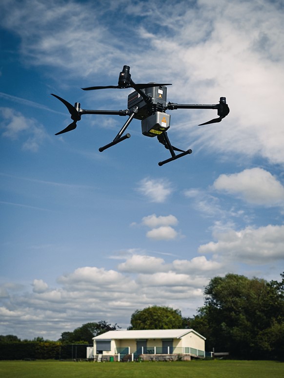
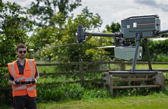
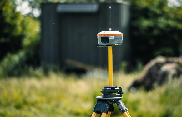
A CHCNAV partner is conducting aerial surveying using an X500 UAV equipped with an Alpha Air 10 LiDAR, supported by an iBase GNSS base station deployed in the field that continuously tracks signals from multiple satellite constellations to deliver real-time, centimetre-level positioning.
Across all of these, the shift from GPS-only to multi-constellation GNSS has been the single biggest factor in extending reliable positioning into places where satellite-based methods were once considered unworkable.
The Four Global GNSS Constellations
The modern GNSS landscape is made up of four fully operational global constellations, each owned and maintained by a different government or economic bloc. A receiver that supports all four gains the geometric redundancy needed to work reliably under partial sky obstruction.
GPS (United States): The original system, operated by the US Space Force. Broadcasts on L1, L2, and L5 frequencies and remains the reference benchmark for availability.
GLONASS (Russia): Uses frequency-division multiple access rather than code-division. Improves sky coverage at high latitudes where GPS geometry can be weaker.
Galileo (European Union): A civilian-operated system designed for high accuracy. Transmits on multiple frequencies and offers a High Accuracy Service that broadcasts corrections directly from the satellites.
BeiDou (China): The youngest of the four and the largest in satellite count. Transmits on frequencies compatible with other constellations, making it straightforward for multi-system receivers to integrate.
Regional systems such as QZSS (Japan), NavIC (India), and a growing family of Satellite-Based Augmentation Systems (SBAS) extend coverage further. For a professional user, the practical takeaway is simple: the more signals a receiver can see, the more stable the position will be when conditions are less than perfect.
GNSS Positioning Accuracy and What Drives It
One of the most common questions from new users is how accurate GNSS actually is. The honest answer is that accuracy depends entirely on the receiver, the observation method, and the environment. A smartphone in an open field will usually place you within three to five metres. A handheld mapping GNSS unit with SBAS corrections will tighten that to under one metre. A surveying-grade receiver running RTK (real-time kinematic) can deliver horizontal accuracy of one to two centimetres in open-sky conditions, updated multiple times per second.
Three technical factors dominate the accuracy budget. The first is multipath, the effect of satellite signals bouncing off reflective surfaces before reaching the antenna. Tall buildings, water surfaces, and vehicles nearby all create multipath. The second is the atmosphere. Signals slow down as they pass through the ionosphere and troposphere, and both effects vary with time of day, solar activity, and weather. The third is satellite geometry, often summarised as the Dilution of Precision (DOP) value reported by the receiver. A low DOP, meaning satellites are well spread across the sky, produces a stronger solution than a high DOP, where the satellites sit in a narrow cluster.
Techniques exist to compensate for each of these. Multi-frequency receivers cancel most ionospheric error. Differential corrections, delivered over radio, cellular, or the internet via NTRIP, remove satellite clock and orbit errors in real time. Post-processing against a reference station network can deliver millimetre-level results for static control points. And where the sky is partially blocked, GNSS-INS integration combines satellite positioning with inertial sensors to maintain continuity through short outages.
GNSS vs GPS: Clarifying the Common Confusion
The difference between GPS and GNSS is straightforward once you know the naming convention. GPS is a specific American constellation. GNSS is the category that contains GPS along with GLONASS, Galileo, BeiDou, and the regional systems. In everyday conversation, GPS is often used as a generic term for any satellite positioning, the way "Kleenex" is used for any tissue. Inside professional surveying, navigation, and geodesy, the distinction matters.
A GPS-only receiver can see roughly eleven satellites from a good location on the ground. A modern multi-constellation GNSS receiver can see fifty or more. That difference is what lets a receiver hold a centimetre fix in a city street where a GPS-only unit would have dropped out repeatedly. It is also why every modern smartphone and every professional tool from the past decade is built around multi-system GNSS rather than GPS alone, even when the marketing still calls it GPS out of habit.
Choosing the Right GNSS Receiver or Service
For a professional buyer, the question is rarely "do I need GNSS" but "which GNSS solution matches my workflow". The answer depends on accuracy target, tolerance for downtime, and the environment the receiver will operate in. A handheld mapping device is appropriate for asset inventory work where sub-metre accuracy is enough. A dual-frequency GNSS rover paired with an RTK base station or an NTRIP correction service is the right choice for detailed topographic survey and construction stakeout. For integration with vehicles, aerial platforms, and marine systems, the right answer often combines GNSS with inertial sensors in a tightly coupled unit, giving continuous output through short signal outages.
CHC Navigation builds GNSS receivers and integrated navigation products across each of these categories, from lightweight RTK rovers for land survey through to dual-antenna GNSS/INS units for autonomy, ADAS testing, and high-end geospatial platforms. The shared thread across all of them is the same principle described above: track as many satellites as possible on as many frequencies as possible, process the measurements carefully, and deliver a position the user can trust in the environments where the work actually happens.
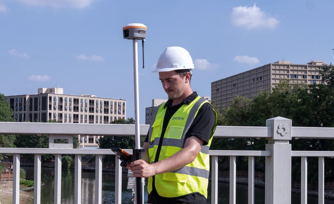
A surveyor performs urban surveying with the i85, a multi-frequency GNSS receiver, that processes signals from several constellations to maintain reliable centimetre accuracy in the built-up environment.
Conclusion
GNSS is the backbone of modern positioning, and understanding the term is more than a matter of vocabulary. It shapes what a receiver can do, where it will work, and what accuracy is realistic to expect. Multi-constellation support, multi-frequency tracking, and proven correction methods are what turn a basic position fix into a tool that professionals across surveying, construction, agriculture, and autonomy can build entire workflows around. Whether the starting point is a simple question like "what is GNSS" or a specific need for centimetre accuracy in a demanding environment, the technology has matured to the point where reliable answers are within reach for almost every use case.
____
About CHC Navigation
CHC Navigation (CHCNAV) develops advanced mapping, navigation, and positioning solutions designed to increase productivity and efficiency. Serving industries such as geospatial, agriculture, machine control and autonomy, CHCNAV delivers innovative technologies that empower professionals and drive industry advancement. With a global presence spanning over 140 countries and a team of more than 2,200 professionals, CHC Navigation is recognized as a leader in the geospatial industry and beyond. For more information about CHC Navigation [Huace:300627.SZ], please visit: https://www.chcnav.com/about/overview
Have a question about our solutions or dealership opportunities?