The Future of LiDAR Point Cloud Processing with Mesh and 3DGS
2025-12-19
LiDAR technology has made high-resolution point cloud capture routine across surveying, construction, and digital reconstruction. The harder question is what to do with that data once it is captured. For decades, mesh modeling has been the foundation of digital environments, from gaming and entertainment to engineering and construction. Now, a new technology is gaining traction: 3D Gaussian Splatting (3DGS). Renowned for its ability to render scenes with photorealistic quality in real time, 3DGS is quickly capturing attention across a wide range of industries.
But can it truly replace the geometrically precise mesh modeling we have relied on for so long? In this article, we explore the strengths and applications of both technologies, how they complement each other, and how tools like CHCNAV CoCloud are putting the combined power of mesh and 3DGS within reach.
What is 3D Gaussian Splatting (3DGS)?
In Simple Terms:
3D Gaussian Splatting (3DGS) is like assembling a digital 3D scene sing countless ellipsoids. Imagine it as a painter using brushstrokes to create a landscape. These ellipsoids, called Gaussian kernels, represent individual 3D data points that come together to form detailed, high-fidelity scenes.
In Detail:
3DGS is a state-of-the-art technique for real-time rendering of 3D scenes, especially those created from large-scale point cloud data. It converts discrete 3D points into smooth, continuous visual representations by "splatting" them onto a 2D screen using Gaussian kernels (3D ellipsoids). Each kernel is defined by parameters such as position, color (RGB), scale, rotation, and opacity. This makes realtime rendering with photorealistic results possible.
The process of building a 3DGS model involves two main steps:
1. Scene Construction: Starting with raw data, such as images or point clouds, the system generates a dense set of 3D points using techniques like feature matching. These points are linked to Gaussian kernels, with each kernel's shape and appearance defined by parameters like scale and rotation. The kernels are then optimized through training methods such as backpropagation to produce high-quality visuals.
2. Scene Rendering: The 3D kernels are projected onto a 2D screen space using a perspective camera model, forming 2D Gaussian distributions. These are then rasterized and blended to generate seamless, photorealistic images for each frame.
A Quick Look at Mesh Modeling
In Simple Terms:
Mesh modeling describes a digital world built from vertices, edges, and faces. These geometric elements define solid shapes and structures within a 3D space.
In Detail:
Mesh modeling is a long-established method for creating 3D environments. It builds objects by connecting vertices to form edges and faces. Each triangular face has a defined topological relationship with its neighboring faces, collectively forming a closed or open geometric surface with a clear and consistent structure.
Unlike 3DGS, which focuses on visual realism, mesh modeling emphasizes precision and structural integrity. It allows for exact measurements, making it ideal for use cases that require detailed spatial analysis or precise design documentation.
Mesh modeling has remained a standard across a wide range of industries. In surveying, it supports accurate landscape mapping. In architecture, it enables the creation of detailed building models. In gaming and film, it helps build immersive and structurally reliable virtual worlds.
Head-to-Head: 3DGS vs. Mesh Modeling
Feature
3D Gaussian Splatting (3DGS)
Mesh Modeling
Core Data Structure
Discrete points + Gaussian kernels
Vertices + triangular faces
Visual Realism
Exceptional. Excels at rendering intricate details like wires, foliage, and light reflections.
Good. Relies on textures and lighting techniques but struggles with complex, non-solid details.
Geometric Precision & Measurement
Medium. Edges are blurred due to point-based rendering, leading to potential measurement inconsistencies across views.
Excellent. Clear vertices and edges enable precise 3D coordinate measurements with consistent results.
Editing & Interaction
Still challenging. Editing relies on complex parameter adjustments, lacking intuitive vertex/face tools.
User-friendly. Direct manipulation of vertices, edges, and faces makes editing and customization straightforward.
Hardware & Performance
Highly efficient rendering but heavily reliant on high-end GPUs for optimal results.
Lower hardware demands, though rendering quality depends more on model optimization than GPU power.
Industry Ecosystem
Emerging technology with limited current software support, but a rapidly expanding ecosystem—new tools, plugins, standards, and community adoption.
Industry standard. Formats like OSGB, OBJ, and FBX are widely supported across platforms.
The Core Argument: Which one to Choose?
From the comparison, it is clear that 3DGS is not a replacement for mesh modeling but a complementary tool designed for different use
cases.
Choose Mesh for Productivity:
In fields where accuracy, measurement, and structured analysis are essential, such as surveying, Building Information Modeling (BIM), and engineering, mesh modeling continues to be the preferred approach. Whether you are measuring building dimensions, calculating earthwork volumes, or performing spatial analyses, mesh models deliver dependable, high-quality digital assets that integrate seamlessly into CAD or GIS workflows. While it may not match 3DGS in terms of visual realism, its advantage lies in precision and practicality.
Choose 3DGS for Immersive Experiences:
In industries that focus on visual impact and user immersion, such as virtual reality (VR), gaming, and digital tourism, 3DGS offers unmatched capabilities for producing rich, photorealistic renderings.
It excels when the goal is to create a vivid digital experience rather than perform technical measurements. For transporting users into a virtual scene, 3DGS is emerging as one of the most powerful ways to visualize LiDAR data in a lifelike and engaging manner.
Computational Challenges and CHCNAV CoCloud’s Solution
One of the main challenges with advanced 3D modeling techniques like 3DGS is the significant computational power they require. High-quality rendering and data processing often depend on top-tier local hardware, especially GPUs. For many users, this can be a limiting and costly barrier.
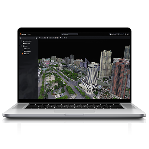
This is where CHCNAV' s CoCloud platform provides a clear advantage. CoCloud uses cloud-based servers to process multi-source data, removing the need for expensive local equipment. It supports both traditional mesh modeling and 3DGS, allowing users to process LiDAR and imagery data entirely online. With CoCloud, users can generate high-precision outputs such as Digital Orthophoto Maps (DOMs) and OpenSceneGraph Binary (OSGB) models without needing specialized software expertise.
For users who do not have access to high-performance GPUs, CoCloud's cloud-native design offers scalable computing resources and storage options ranging from 10 GB to 100 TB. This flexibility ensures that even users with limited local capabilities can still manage resource-heavy tasks effectively. Whether working with large LiDAR datasets or high-resolution imagery, CoCloud delivers strong performance without the need for advanced local infrastructure.
Beyond its processing power, CoCloud also offers flexible API integration and private deployment options. This makes it easy for organizations to incorporate CoCloud into existing systems. As a result, end-to-end workflows, from data acquisition to final output, can be executed efficiently, providing a fully streamlined experience for 3D modeling and LiDAR data processing.
Embrace the Best of Both Worlds
3DGS and mesh modeling each have unique strengths. Mesh continues to dominate industries requiring precision and structured analysis, while 3DGS is rapidly becoming the standard for creating immersive and realistic digital environments. At CHCNAV, we are committed to enabling you to leverage both technologies, enhancing your data acquisition, processing, and visualization workflows.
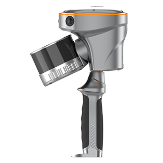
Handheld LiDAR Handheld SLAM 3D Laser Scanner + GNSS RTK, and robust cloud processing platforms like CHCNAV CoCloud, we ensure that you can seamlessly integrate LiDAR data into both precise models and stunning visualizations, empowering professionals to navigate the future of geospatial technology with confidence.
____
About CHC Navigation
CHC Navigation (CHCNAV) develops advanced mapping, navigation and positioning solutions designed to increase productivity and efficiency. Serving industries such as geospatial, agriculture, construction and autonomy, CHCNAV delivers innovative technologies that empower professionals and drive industry advancement. With a global presence spanning over 140 countries and a team of more than 2,000 professionals, CHC Navigation is recognized as a leader in the geospatial industry and beyond. For more information about CHC Navigation [Huace:300627.SZ], please visit: www.chcnav.com
Related Products
CHCNAV CoCloud
Cloud-Based 3D Data Processing and Management Software