CHC Navigation Unveils AU20 MMS: A High-Precision Mobile Mapping System for Detailed 3D Data Capture
2025-07-08
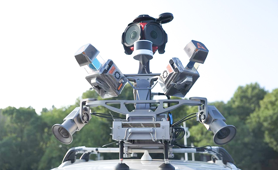
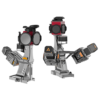
Shanghai, China – July 8, 2025– CHC Navigation (CHCNAV), a global provider of geospatial solutions, announces the release of the AU20 MMS, a vehicle-mounted mobile mapping system designed for accurate and efficient collection of 3D spatial data. Combining high-performance LiDAR technology, versatile sensor support, and intelligent data processing, the AU20 MMS provides a practical and flexible solution for professionals involved in road surveying, asset management, and infrastructure documentation.
Outstanding Accuracy and Data Density
The AU20 MMS is equipped with a sophisticated LiDAR system that utilizes fourth-generation real-time waveform processing (RWP) technology. This enables the system to achieve a scan rate of 2 million points per second and 200 revolutions per second, producing point cloud data with 5 mm accuracy and 3 mm precision. Such detailed capture capabilities allow for the identification of fine surface characteristics and features for comprehensive asset inventories and condition assessments. The system’s long-range, multi-cycle laser technology facilitates high-density data capture up to 250 meters in vehicle-mounted applications.
Versatile Platform and Multi-Sensor Integration
Constructed on the adaptable AP7 vehicle platform, the AU20 MMS can support a dual laser scanner setup, which significantly increases data density. The platform’s design incorporates a 45° scanning angle to reduce data shadows and improve the detection of vertical structures and road signage. Furthermore, the AP7’s built-in processor accommodates the integration of up to eight external sensors, including specialized pavement detection cameras and panoramic cameras such as the Ladybug5+ and Ladybug6, offering users flexibility in data acquisition strategies.
AI-Enhanced Data Processing and Quality
The AU20 MMS leverages AI-based algorithms to refine data quality and streamline processing. AI-driven computation for Vehicle Motion Trajectory (VMA) adjustment automatically identifies control points to correct point cloud inaccuracies to within two centimeters, ensuring the data aligns with highway-grade survey requirements, even in complex scenarios. Additionally, AI-powered panoramic coloring achieves over 95% accuracy in recognizing and handling vehicles and pedestrians, resulting in clean, interference-minimized colorized point clouds through efficient one-click optimization.
Streamlined Workflow with CHCNAV Software Suite
CHCNAV’s proprietary software suite, CoPre and CoProcess, streamlines workflows by integrating intelligent automation. CoPre optimizes data preprocessing, enabling real-time adjustments to point clouds and imagery while minimizing manual intervention. CoProcess leverages AI algorithms for feature extraction, including road assets, terrain models, and building structures, accelerating project delivery.
____
About CHC Navigation
CHC Navigation (CHCNAV) develops advanced mapping, navigation and positioning solutions designed to increase productivity and efficiency. Serving industries such as geospatial, agriculture, construction and autonomy, CHCNAV delivers innovative technologies that empower professionals and drive industry advancement. With a global presence spanning over 140 countries and a team of more than 2,000 professionals, CHC Navigation is recognized as a leader in the geospatial industry and beyond. For more information about CHC Navigation [Huace:300627.SZ], please visit: www.chcnav.com