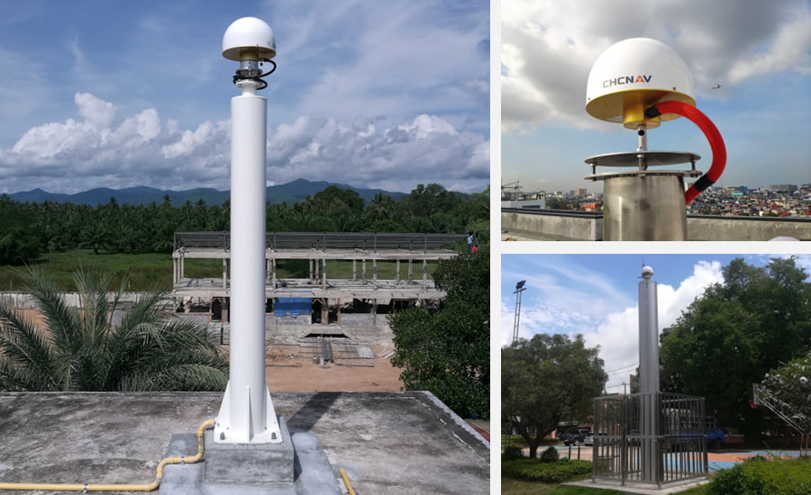
CHCNAV deploys GNSS RTK networks worldwide, a turnkey and affordable solution to provide high-accuracy positioning services anytime, anywhere.
For nearly a decade, CHC Navigation has been deploying GNSS infrastructure around the world, ranging from a corrections service network at local sites such as port automation, to regional coverage for construction engineering projects, and national coverage for surveying applications. The combination of the CHCNAV’s server-based CPS RTK Network software, P5 geodetic GNSS station, and C220GR2 GNSS antenna, provides a powerful enterprise solution for delivering ultimate, accurate, and uninterrupted positioning and navigation services.
What are the different applications supported by a GNSS RTK network?
The demand for more accurate positioning and navigation and access to cost-effective GNSS correction services is growing rapidly to complement existing expensive or aging RTK networks. This demonstrates the relevance of easily deployable modern GNSS networks, which include all global navigation constellations (GPS, GLONASS, Galileo, BeiDou).
CHC Navigation expertise covers the following industries:
- High-precision airborne, marine, and land surveying and mapping
- Unmanned vehicles and robotics applications
- Smart agriculture and automated tractor steering

Figure 1. Advanced GNSS positioning and navigation services from CHC Navigation.
How do ensure uninterrupted GNSS augmentation services?
End-users of GNSS corrections are constantly looking for unlimited access to accurate positioning services, 24 hours a day, 7 days a week. Meanwhile, operators are looking for the perfect combination of a turnkey hardware and software solution that offers an optimal ratio between the total cost of ownership and operational performance.
Responding to these requirements is threefold:
- Rely on an integrated server-based software platform that is scalable for GNSS network expansion, both in terms of coverage and number of users. In this respect, the CHCNAV CPS software, the result of years of scientific development and technical qualification, is perfectly suited. Through optimized analysis of GNSS positioning errors such as ionospheric, tropospheric, orbit, and multipath errors, CPS computes and produces high-quality RTK corrections from single base to virtual network base solution. Supporting direct TCP/IP and NTRIP protocols as well as embedded user management, CPS is the solution for providing reliable CORS and RTK services on a local or large scale.
- Select a reliable, future-proof GNSS geodetic station hardware such as the P5 GNSS, reference station, which ensures superior performance in any environment. Its integrated Linux OS, 624 channels for tracking multi-constellation GNSS signals, large storage, and battery capacity, secure and diverse network connectivity, and intelligent access rights management make the P5 GNSS reference receiver extremely durable and easy to use.
- Install a durable and high-precision GNSS antenna such as the CHCNAV C220GR2, a high-performance GNSS choke ring antenna optimized for reference station applications.

Figure 2. C220GR2 GNSS Antenna.
How to find out about partnership opportunities with CHCNAV for GNSS RTK networks?
Our dedicated team provides full support to ensure a seamless implementation, from initial project costing, site selection, geodetic calibration, and subscription service management platform to operational maintenance of GNSS RTK corrections networks, including:
- GNSS Network construction training and installation support
- Regular firmware and software free updates
- Dedicated professional helpdesk and technical support services
Various partnership models are available from CHC Navigation to gain new customers and grow your business effectively. They include operating 100% proprietary GNSS networks but also joining CHCNAV's global GNSS augmentation services network for closer cooperation.
Our expertise is based on facts with 6000+ stations installed in more than 30 countries, including France, the UK, Bulgaria, Denmark, Morocco, Nigeria, Ivory Coast, Burkina Faso, Kenya, South Africa, USA, Colombia, Peru, Brazil, Thailand, and others. Our current GNSS network partners include seaports, civil engineering and construction groups, construction and land surveying dealers, as well as precision agriculture resellers.
_____
About CHCNAV
CHC Navigation (CHCNAV) creates innovative GNSS navigation and positioning solutions to make customers' work more efficient. CHCNAV products and solutions cover multiple industries such as geospatial, construction, agriculture, and marine. With a presence across the globe, distributors in more than 120 countries and more than 1,500 employees, today CHC Navigation is recognized as one of the fastest-growing companies in geomatics technologies.


