In 2023, CHCNAV introduced the i93 GNSS RTK Receiver, setting a new standard for productivity in surveying with hybrid GNSS RTK, IMU, and dual-camera integration. This innovation boosts efficiency and safety, enabling surveyors to collect precise data even in complex environments. Building on this advancement, CHCNAV expanded its offerings with the i76 GNSS receiver, incorporating vision functionality and real-time positioning accuracy for mainstream surveying. This article explores how CHCNAV’s hybrid technology is reshaping traditional workflows, making surveying more efficient and accurate for mapping professionals.
The Importance of Vision Technology in Surveying
Surveyors have traditionally relied on GNSS RTK rovers to capture location data via GNSS satellite signals and base stations. However, signal disruptions are common, especially in obstructed areas like those beneath bridges or near tall buildings. Interruptions can complicate data collection, particularly in difficult-to-reach locations, such as busy highways or steep slopes, often increasing time, risk, and complexity.
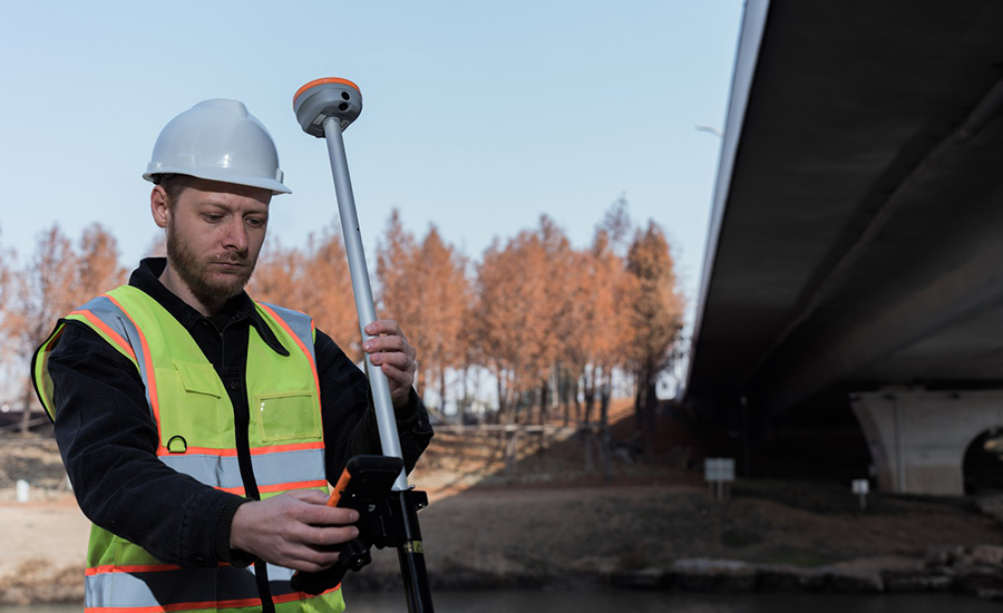
Survey points under the bridge
To address these challenges, CHCNAV integrated dual-camera technology into the i93 GNSS receiver, enabling vision surveying, navigation, stakeout, and 3D modeling. Vision technology provides surveyors with safer, more efficient methods to operate in challenging environments, ensuring precise data collection without unnecessary risk.
Technology Fusion: Enhancing GNSS Surveying Efficiency
The combination of GNSS RTK, IMU, and dual-camera systems in GNSS rovers provides a foundation for accurate, efficient surveying. GNSS RTK enables real-time, centimeter-level accuracy, while the IMU monitors orientation and movement, ensuring data stability in difficult conditions. Dual cameras capture detailed, geo-referenced images synchronized through onboard software, creating accurate visual and positional data. The fusion of technology enables smooth point measurements, 3D modeling, and augmented reality (AR) applications, transforming GNSS rovers into versatile tools for advanced surveying needs.
The 3 Applications of Visual Technology in GNSS Receivers
1.Vision Surveying
The Technology - Vision surveying combines video photogrammetry with GNSS RTK and camera technology to improve measurement accuracy and workflow. The camera captures high-resolution images from different angles, creating a stereoscopic view of the area. By pairing GNSS RTK’s positioning with image geometry, surveyors can identify offset points on the screen, calculating precise coordinates without needing direct physical access.
The Benefits - This feature, available in the LandStar8 software, lets surveyors capture video and select points on the footage to record coordinates for specific locations, such as lane markings or inaccessible road features. Especially valuable in areas with weak GNSS signals, this approach reduces on-site time, lowers risks, and increases productivity by enabling accurate data collection from otherwise inaccessible locations.
2.Visual Navigation and Stakeout with Augmented Reality
The Technology - Augmented reality (AR) in GNSS surveying combines RTK positioning with dual-camera systems for precise stakeouts. CAD models overlay real-world views, allowing surveyors to align virtual designs with site features accurately. CHCNAV’s Meta CAD engine in the LandStar8 software integrates CAD files into real-world visuals, enabling surveyors to see CAD markers overlaid on live views.
The Benefits - Traditional stakeouts require repeated adjustments to align with coordinates, but AR-driven technology guides surveyors in real-time, significantly speeding up the process. The overlay of CAD elements on live views enhances accuracy and minimizes errors, giving surveyors a clear, intuitive connection between design and on-site layout.
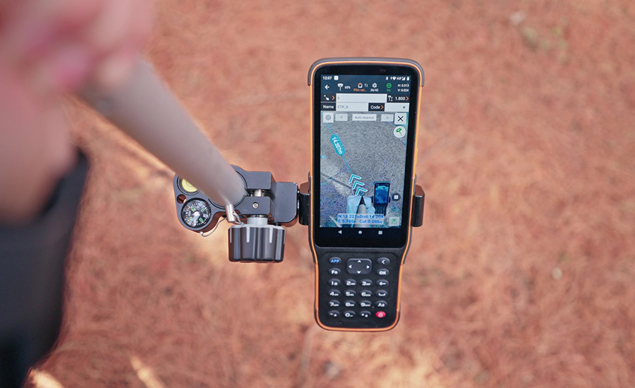
Visual Navigation function of LandStar
3. 3D Modeling for Detailed Digital Representations
The Technology - CHCNAV’s GNSS receivers combine GNSS RTK with a camera system to create precise, geo-referenced 3D models. The camera captures spatially aligned images, while GNSS RTK provides centimeter-level accuracy, which photogrammetry software processes to produce high-resolution 3D models of landscapes, structures, and features.
The Benefits - High-quality 3D modeling supports detailed project planning and analysis. For surveyors, this means easy capture of complex data for buildings, landscapes, and infrastructure, making it invaluable for engineering and planning applications. The intuitive software ensures accurate model creation while reducing field time.
Integrating Aerial and Terrestrial Data for Comprehensive 3D Models
Aerial surveys are effective for large areas, but obstructions such as eaves or tree canopies can challenge data capture. Traditional methods required manual photos and extensive post-processing to fill gaps. With its video-based GNSS RTK, CHCNAV’s vision technology supports video capture of these areas, using software to generate images with Position and Orientation System (POS) data. This integration with aerial data enables seamless 3D model correction, saving time and enhancing model accuracy.
CHCNAV’s solutions include both manual modeling and AI-powered cloud-based options. Data can be exported to popular modeling software like CloudCompare or Smart3D, or uploaded for AI-based automatic generation, providing flexibility and efficiency for fast project turnarounds.
In a recent demonstration at its headquarters, CHCNAV demonstrated the i93’s capabilities by combining drone data with video footage from the i93 receiver to accurately model obstructed areas, such as eaves and observation towers. The streamlined process corrected distortions, offering clear textures and accurate details, proving the efficiency of CHCNAV’s GNSS receivers over traditional manual correction methods.
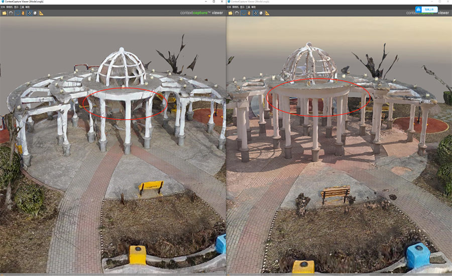
Using i93 to supplement the model by visual technology
Advancing Precision and Efficiency in Surveying with CHCNAV’s Vision Technology
CHCNAV’s integration of vision technology addresses core surveying challenges like signal obstructions, inaccessible points, and lengthy model corrections. With features such as Vision Survey, Navigation and Stakeout, 3D Modeling, and AR Stakeout, CHCNAV provides a suite of tools to enhance data accuracy, streamline workflows, and improve on-site safety.
The adoption of these advanced vision technologies is transforming surveying by enabling professionals to work more safely and efficiently. CHCNAV’s commitment to hybrid GNSS, IMU, and dual-camera systems equips surveyors with the precision tools needed to capture, model, and stake out designs confidently, even in challenging conditions. Through innovation in vision technology, CHCNAV is setting a new standard for productivity and quality in the surveying industry.
____
About CHC Navigation
CHC Navigation (CHCNAV) develops advanced mapping, navigation and positioning solutions designed to increase productivity and efficiency. Serving industries such as geospatial, agriculture, construction and autonomy, CHCNAV delivers innovative technologies that empower professionals and drive industry advancement. With a global presence spanning over 140 countries and a team of more than 2,000 professionals, CHC Navigation is recognized as a leader in the geospatial industry and beyond. For more information about CHC Navigation [Huace:300627.SZ], please visit: www.chcnav.com