Open-pit mining is a highly efficient method for extracting resources on a large scale. Heavy machinery is used to create benches, allowing minerals to be excavated and transported to the surface for processing. However, altering landscapes and rock structures significantly increases the risk of geotechnical hazards.
This article highlights the importance of deformation monitoring in identifying geotechnical risks in open-pit mining. It also reviews various monitoring technologies, with a focus on how GeoSAR systems provide advanced solutions to improve safety and maximize operational efficiency.
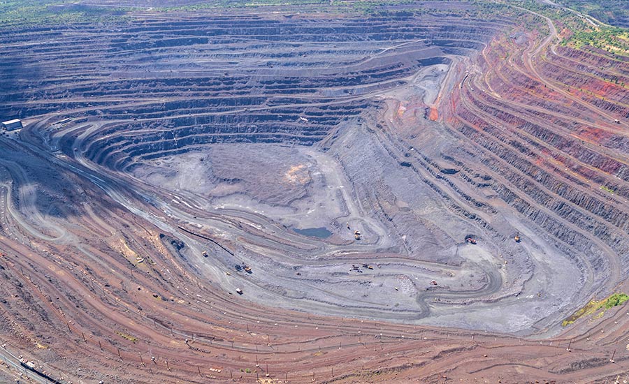
An operating open-pit mine
The Importance of Deformation Monitoring in Open-Pit Mining
In open-pit mining, deformation monitoring is essential for protecting workers, equipment, and operations. Excavation activities constantly change the geological stability of the site, raising the risk of slope failure and other geotechnical hazards.
These hazards typically result from a combination of key factors:
- Geological Conditions: Features such as faults, sliding planes, and folds inherently destabilize rock structures.
- Mining Activities: Blasting and excavation disrupt the natural stress balance within rock formations.
- Hydrological and Environmental Factors: Water infiltration, heavy rainfall, and freeze-thaw cycles progressively weaken slope integrity, further compromising stability.
Deformation monitoring offers early warnings, enabling proactive measures to mitigate risks and prevent catastrophic failures. Key benefits include:
- Worker Safety: Early detection of potential hazards allows for timely evacuations and implementation of preventive measures.
- Operational Continuity: Monitoring helps prevent slope failures that could disrupt operations for extended periods, avoiding significant financial losses.
- Cost Reduction: Identifying risks early minimizes the likelihood of costly equipment damage, production downtime, and resource waste.
- Regulatory Compliance: Ensures adherence to safety and environmental standards, helping maintain legal and operational integrity.
To mitigate these risks, mines employ a variety of safety measures, including:
- Reinforcing Unstable Rock: Securing hazardous areas with anchors, rock bolts, or other stabilizing equipment to prevent structural failures.
- Installing Protective Barriers or Ditches: Shielding personnel, equipment, and infrastructure from falling debris and other potential damage.
- Implementing Advanced Monitoring Solutions: Leveraging technologies like GeoSAR to deliver early warnings and support proactive risk management.
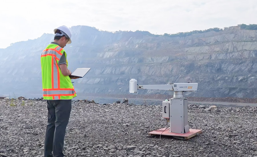
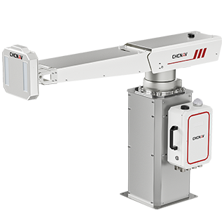
An engineer is commissioning a newly installed PS-2000
Overview of Monitoring Technologies for Open-Pit Mining
Geological hazards in mining, such as landslides, rarely happen without warning. Like a sprinter preparing before the starting gun, these events are often preceded by small, gradual deformations that speed up over time and become visible only in later stages. Precision monitoring technologies can detect these early signs, enabling timely interventions to minimize risks.
Various monitoring methods are available for open-pit mining, each offering unique benefits for assessing slope stability and ground movement:
- Total Stations: These devices measure angles and distances with high precision to track surface displacements. They are effective for localized monitoring but require significant setup and frequent manual adjustments, especially in high-risk or inaccessible areas.
- GNSS Sensors: These systems provide real-time, accurate data on surface movements. However, their effectiveness is limited in areas with poor satellite visibility or physical obstructions.
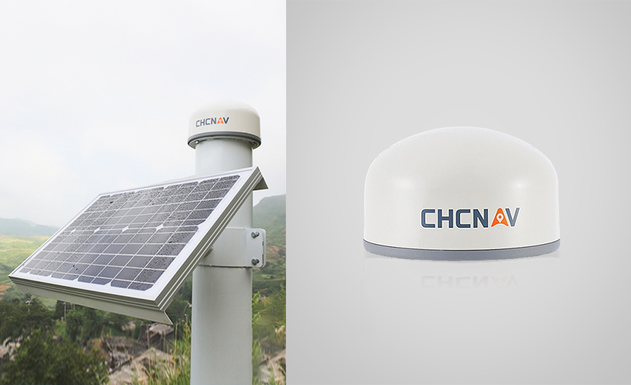
CHCNAV H3 GNSS Monitoring Receiver
- GeoSAR Systems: Technologies like CHCNAV’s PS-2000 use Synthetic Aperture Radar (SAR) to monitor ground deformation across large areas. GeoSAR is highly effective in all weather conditions, making it an ideal choice for continuous monitoring in open-pit mining.
Why GeoSAR Technology Excels in Open-Pit Mining Monitoring
GeoSAR technology has transformed deformation monitoring in open-pit mining. Its capability to detect millimeter-scale ground movement in near real-time makes it a top choice for mine engineers focused on safety and operational efficiency.
- Wide-Area Coverage: GeoSAR systems, such as CHCNAV’s PS-2000, monitor deformations over a broad radius, offering 360-degree coverage with a vertical angle of 30 degrees. This surpasses total stations, which are limited by environmental conditions like dust and weather and require prisms for extended range—a challenge in high-risk or inaccessible areas. GNSS receivers, designed for single-point monitoring, also rely on power and network connectivity, making them better suited as complementary tools for radar blind spots.
- Adaptability to Dynamic Terrain: Open-pit mines constantly change as excavation progresses, creating new surfaces that require immediate monitoring. While GNSS receivers and total stations need physical installation on these new areas, GeoSAR systems can instantly scan and provide updated data without additional setup, ensuring fast and safe monitoring.
- Comprehensive Coverage for Randomized Deformation: Deformations in mining areas are often irregular and unpredictable, requiring dense monitoring to identify subtle shifts. Unlike applications like dam monitoring, which focus on fewer stable points, open-pit mining demands extensive coverage. GeoSAR’s advanced scanning capabilities deliver a complete deformation picture, offering a significant advantage over point-based methods like GNSS receivers and total stations.
Case Study: Enhancing Slope Safety in a Laos Gold Mine
Project Overview - A gold mining operation in Laos faced important geotechnical challenges. To monitor slope stability and improve safety, CHCNAV deployed the PS-2000 Multi-Point Deformation Monitoring System. The system’s modular design allowed for quick installation, while CHCNAV’s technical team ensured smooth setup and reliable monitoring data transmission.
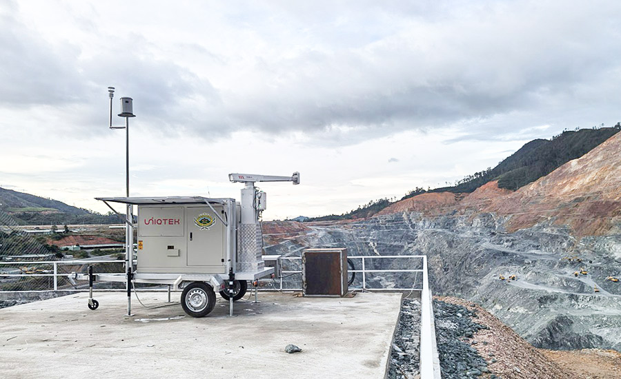
The PS-2000 is operating in the Laos
Tailored Solutions - The PS-2000’s flexible design was essential during urgent project phases. Its easy installation minimized delays and downtime. CHCNAV provided on-site training to help the client’s team operate the system independently. Later, the system was transitioned to a permanent setup with extra training and support to maximize its performance.
Measurable Results - The PS-2000 delivers real-time alerts, helping mine operators address landslide risks early and monitor slope stability with accuracy. The system works reliably in tough conditions, improving safety for workers and protecting mine infrastructure.
Enhancing Mine Safety with GeoSAR Technology
As open-pit mining operations expand in scale and complexity, the demand for advanced monitoring solutions grows. GeoSAR technology, such as CHCNAV’s PS-2000 Multi-Point Deformation Monitoring System, offers millimeter-level precision for detecting ground deformation. Its ability to function in all weather conditions and cover large areas gives it a significant edge over traditional methods.
Integrating GeoSAR allows mine engineers to manage risks proactively, ensure worker safety, and protect critical infrastructure. From slope stability monitoring to operational safety, GeoSAR provides reliable and efficient solutions for mine monitoring. As seen in the Laos gold mine case study, these technologies are both effective and adaptable to changing needs.
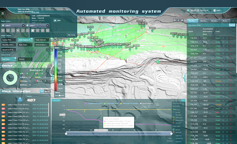
Interface of monitoring system
CHCNAV’s systems combine real-time monitoring with advanced analytics, enabling mining professionals to make informed decisions while maintaining safety and operational continuity.
____
About CHC Navigation
CHC Navigation (CHCNAV) develops advanced mapping, navigation and positioning solutions designed to increase productivity and efficiency. Serving industries such as geospatial, agriculture, construction and autonomy, CHCNAV delivers innovative technologies that empower professionals and drive industry advancement. With a global presence spanning over 140 countries and a team of more than 2,000 professionals, CHC Navigation is recognized as a leader in the geospatial industry and beyond. For more information about CHC Navigation [Huace:300627.SZ], please visit: www.chcnav.com
.png)