CHC Navigation (CHCNAV) is delighted to announce the CoProcess 2025 Launch Webinar, taking place on August 14, 2025, at 1:00 PM (UTC).
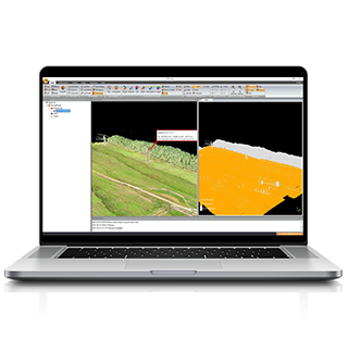
CoProcess 2025 is CHCNAV’s advanced LiDAR data processing software tailored for the post-processing of massive point cloud datasets. It seamlessly transforms field-captured LiDAR data into a variety of multi-format deliverables. Designed with powerful point cloud management, automated feature extraction, and advanced visualization capabilities, CoProcess 2025 is an essential tool for professionals in urban planning, infrastructure development, and more.
Key Highlights of CoProcess 2025
Automated Processing – Process point clouds, extract road and building features, and conduct section and cross-section analysis automatically.
Advanced Reconstruction – Generate DEMs, DSMs, and road models with high efficiency.
Powerful Feature Extraction – Automatically or manually extract road features, building contours, doors, and windows; export to SHP/DXF for seamless CAD/GIS integration.
Massive Data Classification – Efficiently manage and classify large-scale datasets.
User-Friendly Interface – Streamlined workflows for maximum productivity.
Comprehensive Visualization – Clear, efficient, and detailed 3D data rendering.
Save the Date
August 14, 2025, at 1:00 PM (UTC)
Join Us Live
We invite you to join our live webinar to explore how CoProcess 2025 can transform your SLAM-based workflows. Engage with our experts, discover the latest innovations, and see firsthand how CHCNAV continues to redefine geospatial technology.
____
About CHC Navigation
CHC Navigation (CHCNAV) develops advanced mapping, navigation and positioning solutions designed to increase productivity and efficiency. Serving industries such as geospatial, agriculture, construction and autonomy, CHCNAV delivers innovative technologies that empower professionals and drive industry advancement. With a global presence spanning over 140 countries and a team of more than 2,000 professionals, CHC Navigation is recognized as a leader in the geospatial industry and beyond. For more information about CHC Navigation [Huace:300627.SZ], please visit: www.chcnav.com

.png)